|
|
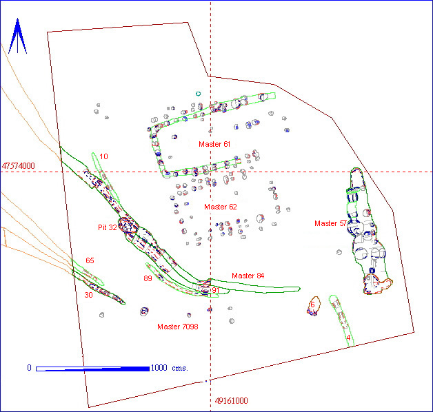
The underlying geology was chalk, although a thin layer of hillwash
(22 metres long by 8 metres wide) was located ![]() in the central western part of the area. A number of features were clearly
visible following the machine stripping, including the southernmost extent
of the settlement boundary ditches and an unusual north-south oriented
feature situated in the eastern part of the area. Although it was evident
that two posthole structures were also present, the actual visibility of
the post holes on the ground was poor, particularly for the southernmost
(012AE00062) structure, which was partially
cut into the layer of hillwash. The position of the post holes became much
more obvious shortly after rain, when differential drying of the material
within the post hole and the surrounding subsoil gave a very clear picture
of their location.
in the central western part of the area. A number of features were clearly
visible following the machine stripping, including the southernmost extent
of the settlement boundary ditches and an unusual north-south oriented
feature situated in the eastern part of the area. Although it was evident
that two posthole structures were also present, the actual visibility of
the post holes on the ground was poor, particularly for the southernmost
(012AE00062) structure, which was partially
cut into the layer of hillwash. The position of the post holes became much
more obvious shortly after rain, when differential drying of the material
within the post hole and the surrounding subsoil gave a very clear picture
of their location.
In addition, the high ![]() resolution geophysics
over this area gave additional information on the location of the post
hole structures.
resolution geophysics
over this area gave additional information on the location of the post
hole structures.