The Aims, Objectives and Research Design for the Heslerton Parish Project
There are certain regions of the British Isles which have long been recognized
as areas of primary archaeological importance. One of these, Eastern Yorkshire,
comprises three distinct geomorphological areas; the North Yorkshire Moors,
the Vale of Pickering and the Yorkshire Wolds. Archaeological work has
been in progress in the area since the late 18th Century and the work of
pioneers such as Greenwell and Mortimer has been fundamental in developing
the basic corpus of information which now forms an essential element in
the literature of prehistoric studies. Subsequent work by Brewster, Manby
and others has developed this body of information and clearly emphasized
the traditional view of the area's importance, particularly in the field
of British Prehistory.
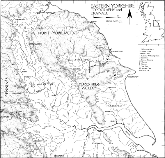
Figure 1 Location of the Parish Project area (after
Powlesland et al, Arch J, 143 (1986) page 54)
The Heslerton Parish Project was set up in 1980 to form
the framework for major archaeological work, both rescue and research,
into which the evolution of the landscape of Eastern Yorkshire, an area
of established national significance, could be placed. At this time, references
to assessments of the prehistoric and Anglian evidence emphasized the sepulchral
bias: Longworth (1961), Simpson (1968), Clarke (1970), Cunliffe (1974)
and Rahtz, Dickinson, Watts (1980). It was also clear from statements made
by the Prehistoric Society in 1978, that a number of archaeological bodies
were developing a "landscape strategy". They stated that it was vital "...
to establish as wide a range as is possible of environmental, economic,
chronological and social evidence." The general statement was qualified
by a number of conditions which should be met in the selection of "nationally
important projects". These included sites with well preserved organic material,
sites sealed beneath alluvial, colluvial or aeolian deposits, sites where
environmental, economic or structural evidence is preserved and settlement
or cemetery sites where total or substantial excavation is possible. Work
carried out at Sherburn and West Heslerton had indicated that most if not
all of those conditions could be satisfied by the parishes along the southern
edge of the Vale, while suitable sites satisfying the wide range of conditions
must be rare on either the Wolds or the Moors.
Heslerton: A sample of The Yorkshire Landscape
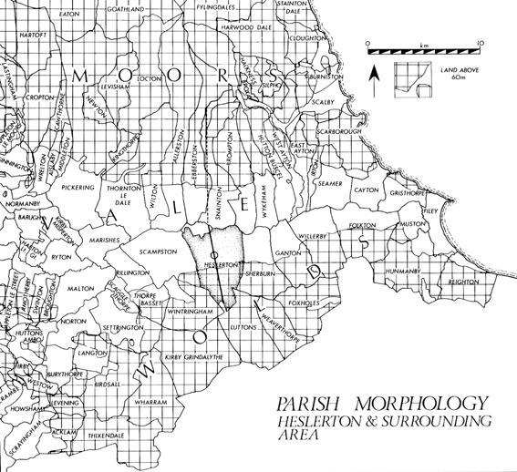
Figure 2 Parish morphology in the Project area
(after Powlesland et al, Arch J, 143 (1986) page 56)
There has been much discussion relating to the division
of the English landscape into parishes. It should therefore suffice to
say that the parish structure developed at an early date and, more importantly,
that it developed on an economic base which gave the population access
to a wide range of environmental and economic zones. In the Vale of Pickering
there is a high degree of uniformity in the morphology of the parishes
both to the north and to the south of the River Derwent. All of those within
each group, except the small monastic parish of Yedingham which controls
the highest navigable point of the Derwent, cover roughly equal areas of
high and low ground. Each parish contains the complete range of available
micro-environments and thus any parish could provide a widely relevant
sample which could be used to create a model for the area as a whole. The
nodal position of Heslerton, the extent of past and current work in the
parish and the presence of a major archaeological threat in the form of
a sand quarry cutting across a broad zone of stratified deposits, all led
to the selection of Heslerton parish as a representative sample of the
landscape running from the banks of the River Derwent to the top of the
Wolds.
Past Work in the Area
The distribution of known archaeological remains at the outset
of the project indicated the extent of past work and emphasized the relative
dominance of certain areas. Work had concentrated on the Wolds, due to
the large number of upstanding field monuments, while the Moors provided
a major centre for palynological studies. The Vale of Pickering was dramatically
defined by the apparent paucity of archaeological evidence. Until the late
1970's and early 1980's it remained almost entirely unexamined from the
air or the ground. Even the major discoveries at Star Carr and Flixton
Carr failed to generate a large scale program of fieldwork (although see
Schadla-Hall). While the evidence pertaining to the prehistoric occupation
of Eastern Yorkshire dramatically demonstrates the importance of the area,
it is clear that the evidence is almost entirely confined to that gained
from sepulchral deposits. The detailed evidence of settlement and economy
that would help us to understand the dead populations has been neglected
to an almost exclusive degree. Evidence recorded by 19th Century
fieldworkers and more recently by Manby, show that the chalk areas have
suffered severe erosion by both natural and human agencies from a very
early date (Manby 1975). With the exception of some major sites such as
Thwing, Garton/Wetwang Slacks and Staple Howe, it consists of nothing more
than isolated pits. The potential for the recovery of a comprehensive range
of prehistoric and later evidence on the Wolds is limited by a number of
irredeemable factors. With the exception of small isolated deposits sealed
by surviving earthworks or colluvium, the vast majority of the evidence
has been swept away.
A considerable body of work has been carried out in Heslerton
Parish over the past 150 years. Recorded work began with Canon Greenwell's
identification of a long barrow at Heslerton Wold, which he described as
having been "entirely destroyed" in 1868 (Greenwell 1877). This was probably
that excavated by the Vatchers, though this, The East Heslerton Long Barrow,
still survives as a very slight earthwork (Vatcher and Vatcher 1965). It
proved to be typical of the Yorkshire series of cremation long barrows.
Greenwell also examined three round barrows in the parish (Greenwell barrows
IV, V and VI). Barrow VI produced a number of features which are typical
elements of the Yorkshire cremation long barrow tradition, namely a facade
bedding-trench and a ritual pit, as well as a quantity of Neolithic pottery.
The two other barrows showed a high degree of organic preservation with
seeds recorded in barrow IV and what Greenwell thought to be preserved
leather in barrow V. A prehistoric burial accompanied by a jet necklace
of Food Vessel type was located within the confines of West Heslerton (Site
1) and recorded by Brewster (pers comm) in 1968. Brewster's work,
both as a teacher running one of the first field-walking programmes in
this country and as an excavator introducing the local population to archaeology
in its widest sense, laid the foundations upon which the current project
is based. His identification and excavation of the two pallisaded enclosures
at Staple Howe (in the adjacent parish of Scampston) and at Devil's Hill,
located on a knoll on the Wold escarpment, represent an important aspect
of Late Bronze Age/Early Iron Age occupation in the area and the North
of England as a whole (Brewster 1963; 1981). A high degree of local understanding,
as encouraged in this case by Brewster, is essential for the success of
a broad-based landscape research project.
Geomorphology of the Parish
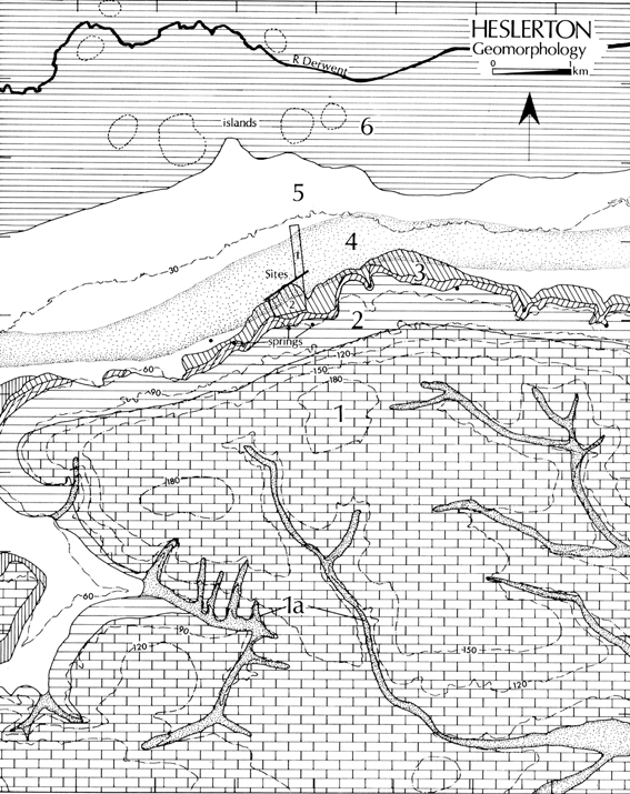
Figure 3 Geomorphology of the Parish Project area (after
Powlesland et al, Arch J, 143 (1986) page 57)
For the purposes of the project the small parish of Yedingham
(which includes the remains of a Benedictine Abbey) has been included in
the scheme; it is almost entirely enclosed by the boundary of Heslerton
parish to the south and by the river Derwent to the north. It was decided
to look at an area 10km by 10km square, with Heslerton parish in the centre
of the area. It was felt that this area would allow for the development
of the parish to be set firmly in its position in the evolution of the
landscape. The project design for research into the development of a landscape
presupposes a number of assumptions. Firstly that there is a direct relationship
between human activity and the geomorphology of a given area, a situation
which certainly existed before the Medieval period when continuous control
of the environment took place. Secondly that parallel zones of geomorphology
and environment will also reflect a similar past thereby enabling the data
recovered to be extrapolated to a wider area. These assumptions accepted
it would seem to be essential to first examine and define the differing
geomorphological zones present in the parish. In simple terms the parish,
which covers an area of circa 26.5 square kilometers, encompasses roughly
equal areas of the Yorkshire Wolds (dry upland) and the Vale of Pickering
(wet lowland). On more detailed examination these two areas can be broken
down into six distinct zones which form the landscape entities as defined
by geology, relief, drainage and to a certain extent micro-climate, as
well as the archaeological evidence of past activity.
Zone One - The Wold Top
The largest zone comprises an area of open chalk downland.
It is defined to the north by the 150m contour and elsewhere by dry valleys
containing extensive deposits of alluvial sands and gravels frequently
capped by colluvium (Zone 1A). The archaeology of this zone is most dramatically
demonstrated by the upstanding monuments, the ditch and bank systems (the
Wold Entrenchments) and the barrows. The extent of modern erosion is indicated
by the wealth of levelled crop mark sites of similar features. Only beneath
the upstanding earthworks or beneath colluvial deposits in the dry valleys
is any stratigraphy likely to have survived, though important environmental
deposits must be preserved beneath the banks of the Entrenchments. Though
this system of major boundary works has clearly had an influence on the
land division of the chalk areas for a very long period of time, they remain
an enigma having been the subject of only minimal examination.
Zone Two - The Wold Scarp
This zone, contained by the 150m and 90m contours, incorporates
the steep, north facing scarp of the Wolds, where the steep incline has
restricted the development and build up of fertile soils. That this zone
is of considerable archaeological importance, despite the restrictions
imposed by local geography, is demonstrated by the situation of two important
Late Bronze/Early Iron Age pallisaded enclosures on steep-sided knolls
within this zone, at Staple Howe and Devil's Hill. Similar sites can be
postulated at regular intervals both to the east and to the west.
Zone Three - The Wold Foot
This zone spans the basal red chalk and the Speeton clay
deposits, and is located between the 90m and 50m contours. The presence
of the spring line at the junction of the chalk and the clay gives the
zone a particularly high potential. Both the present day villages of East
and West Heslerton are centered in this zone. A number of buried or relict
stream channels are indicated by aerial photography of the area.
Zone Four - The Aeolian Deposits
Zone four was defined by the rescue excavations of 1977-1985
(Heslerton sites 1 and 2), and consists of areas of windblown sand, which
serve to conceal and protect old ground surfaces and structural remains,
in places with up to a depth of three metres. The blown sands, which are
derived from a much more extensive deposit of post glacial sands and gravels
beneath them and to the north, have been accumulating since the late Neolithic
period at least, though the mechanics of the process over time are far
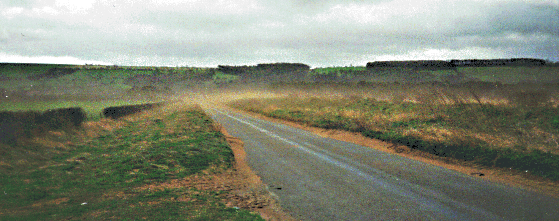
from perfectly understood. The process continues today, as seen in the
photograph above, taken in March, 1998. Crop mark evidence is here unreliable,
due to the great depth of overburden, while field walking cannot hope to
give details of activity sealed well below the plough soil. Remote sensing
and geophysical surveying can give reliable results when the windblown
sand cover is restricted to depths of less than and up to a metre, but
for the deeper deposits only chance discovery during destruction coupled
with intensive fieldwork can be used to assess the full potential of the
sealed deposits.
Zone Five - The Dry Vale
An area of post glacial sand and gravel, zone five is bounded
to the south by the overlying aeolian sand deposits and to the north by
the lacustrine clays of zone six. Crop mark evidence indicates that this
area of light soils experienced the same level of activity recognizable
in zone four, and suggest that they cover a number of periods. Central
to this zone is a continuous series of ladder settlements and field systems
(of late Iron Age/Romano British date) which can be traced for circa 15km
along the 27 to 30m contour lines in the southern part of the Vale. There
is a corresponding ladder settlement in the northern part of the Vale,
although this settlement is not so well attested by the aerial photographic
evidence. Possible gaps in the aerial photographic record may indicate
particularly well preserved areas of the settlement, covered by aeolian
deposits, while particularly well-defined areas, where even individual
hut circles can be identified, may prove to be the most seriously damaged
by modern agricultural methods.
Zone six - The Wet Vale
Zone six incorporates the small parish of Yedingham, and
comprises a large flat area of lacustrine clays, frequently cut by relict,
and now peat filled stream channels, and including a number of slightly
elevated gravel islands. Although Zone six would have supported a fenland
environment during the later prehistoric period, successive drainage schemes,
particularly during this century, have dried out the greater part of the
area, in order to facilitate the present intensive arable farming.
Methodology - The Parish Transect
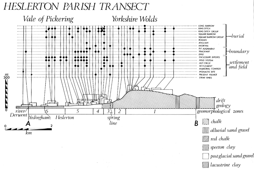
Figure 4 The Parish Transect (after Powlesland et al,
Arch J, 143 (1986) page 58)
The analytical model upon which the project is focused
is the Parish Transect. This brings together the different factors of geomorphology
and archaeology and cuts across the "grain" of the landscape at right angles.
The raw data with which the project began consisted of aerial photographic
plots combined with a limited amount of fieldwork plotted against the geomorphology.
The purpose of the project was to refine this working model by more detailed
examination of all the potential sources of evidence in order to develop
a detailed understanding of the landscape in both spatial and chronological
terms. The excavations at Heslerton have clearly indicated the potential
for developing the model to expand our knowledge of the complex socio-economic,
climatic and geomorphological factors and their inter-relationship in the
evolving landscape. By the selective application of similarly detailed
analysis of the other geomorphological zones in the parish it should be
possible to expand the knowledge to a degree which would have major implications
for the understanding of an important archaeological region.
Methods and Resources
In order to understand the development and evolution of a
landscape, even when this study is limited to a 10km by 10km square, the
widest range of methods must be applied. As well as using the tried and
tested methods, the Heslerton Parish Project has been at the forefront
of developing new techniques in excavation as well as assessing different
methods of remote sensing and their possible applications to an archaeological
understanding of the landscape.
Aerial Photography
The aerial photographic programme continued on an intensive
basis up till 1984, by which time it was felt that nothing less than a
massive increase in flying time, or a change in agricultural methods, would
substantially increase the number of known sites. A number of high resolution
colour vertical photographs of the area were obtained by the NERC during
June 1992, a particularly good year for the development of cropmarks, and
these enhanced the number of sites, although more often providing greater
detail of known sites.
Preliminary tests indicated that soil conditions in the parish
were conducive to the application of geophysical prospecting techniques.
This has since been proven on a number of the different geomorphological
zones, with results ranging from average to excellent. It is planned that
further geophysical surveying will take place at regular intervals, both
to enhance the known archaeology and to investigate the apparent "blank"
areas in the coverage.
The project also pioneered the use of high
resolution geophysics after the removal of the plough soil, which,
allowing for the already proven high magnetic susceptibility of the site,
produced some spectacular results.
Environmental Survey
It was considered that the undertaking of an environmental
survey was of prime importance. A detailed examination of the environmental
deposits, whether preserved in peat or beneath earthworks, would have significance
for the region as a whole, perhaps allowing sites examined in the parish
to be tied in and compared with others in the region, both on the Wolds
and on the Moors. The survey was to have included the preparation of detailed
soils maps, the sampling and identification of the areas of greatest environmental
potential within each geomorphological zone and the identification of threats
to environmental deposits by agricultural or other agencies.
Documentary Survey
Initial documentary work was carried out, which proved that
by the time of the Domesday survey, the current position with two villages
(West and East Heslerton) was already in place (Eslerton and the Other
Eslerton). By the 17th Century the villages were known as Great
and Little Heslerton. A number of medieval earthworks, a monastic and a
manorial site are known in the parish, all of which should prove of importance
as further documentary work is to be carried out in the near future.
Remote Sensing
Remote sensing, in its widest possible context, can be defined
as being the attempt to gather data or evidence using non-invasive techniques.
For our purposes, we will deal with geophysical surveying under a separate
heading, reserving remote sensing for the aerial or satellite gathering
of data. While not part of the original project objectives, developments
in the field of remote sensing soon made it apparent that these techniques
could be of use to the archaeologist. The project, through academic links
with the Department of Geography, Durham, was able to acquire both a SPOT
image and a multi-spectral image (acquired by the NERC) covering the project
area. Analysis of the images is ongoing, but the initial results prove
the great potential of remote sensing as a powerful tool for the archaeologist.
Excavation
A total of approximately 19 hectares were excavated at West
Heslerton between 1977 and 1995.
Field Walking
A field walking programme was to be initiated to provide
evidence of date, function and damage to known cropmark sites. It was also
proposed that apparent negative areas be investigated, as experience had
shown that this view could be highly misleading.
Bibliography needed
Brewster
Manby
Longworth (1961)
Simpson (1968)
Clarke (1970)
Cunliffe (1974)
Rahtz, Dickinson, Watts (1980)
Prehistoric Society (1978)
Greenwell, W. and Rolleston, G. 1877, British Barrows, Oxford.
Mortimer, J.R. 1905, Forty Years Researches in British and Saxon
Burial Mounds of East Yorkshire, London